Sometimes a little change can make a big difference, and often you have to wait for the right moment to propose those changes. Our executive director had been eyeing the Boggy Creek Trail for an improvement in how it exists onto Webberville since he uses the trail almost daily and when the current construction at the Connoly-Guerro Senior Activity Center force pedestrians and cyclists to self route around the blocked off sidewalk and parking lot, the time became now. Not only did the organically created trail match the proposed route on paper, it demonstrated that it is an extension that users would most likely use should it exist as a permanent designed trail.
Currently the SE section of the Boggy Creek Greenbelt Trail ends at the Connoly-Gurerro Senior Activity Center and transitions onto the sidewalk between the parking lot on one side and the activity center, playground, and Rosewood Zaragosa Heath Center on the other. This sidewalk is used by elderly and/or mobility challenged individuals, children at play and other pedestrians. Users which are exiting their cars or the parking lot generally do not expect bicycles on what seems like a private walkway for the centers and typically do not check both directions prior to entering the shared sidewalk.
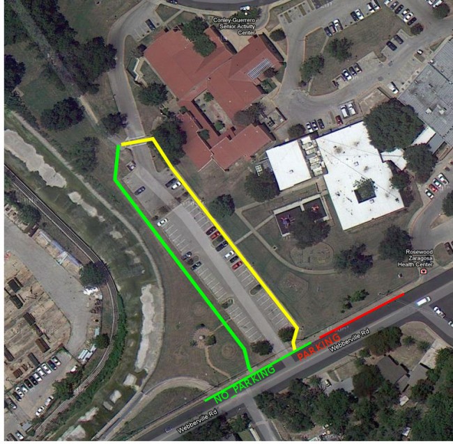
Due to the construction at Connoly-Guerro this above mentioned route has been closed which has caused the creation of a rider and jogger created trail, due to repeated use, along the outer edge of the parking lot. It exits onto Webberville via a pre-existing vehicle width curb cut and also has improved visibility when entering Webberville due to a wide length of no-parking along the curbside edge. So, not only does this remove a usage conflict between trail users (cyclists, joggers, walker, dogs on leash, etc) and more traditional sidewalk users and children accessing the playground, it creates a safer transition for cyclists onto Webberville due to both increased line of sight (currently limited due to parked cars) and separation from the parking lot exits which they also are on the wrong side of (input rather than output).
Were the trail to visibly exit the park to the left of the parking lot entrance using the existing but unused curb-cut, it would be possible to install signage of the existence of the trail which at this time is a bit hidden unless you already know it exists on the far side of the divided parking lot. It would also tie the trail into the existing art/landscaping installation along Webberville.
Below is an overhead image with both the current route (yellow) and the proposed permanent (decomposed granite) and user created route (green) along with the no-parking and parking zones at the “trail head”. There are also a number of site level images showing each of the existing routes. This isn’t an official Ghisallo Cycling Initiative project yet as the Parks and Rec Department is still reviewing the proposal, but should they view it favorably, we will pursue it in 2013 and work with other stake holders such as the Rosewood Neighborhood Contact Team and the Friends of Boggy Creek Greenbelt, Rosewood, group who have adopted the park, to ensure it is a success.
